geoLibro

2007.February.6

Plug Up ka-Map

Filed under: GISUI (GIS User Interfaces), Open Source GIS — geoLibro @ 1:32 am

This is going to work out fine, yes. I’ve been toying with the notion that the open source ka-Map might just be smooth enough (built on top of MapServer‘s robust enough) to handle some of the web mapping projects we have coming up. ka-Map is a javascript and php-built front end that takes MapServer’s output and tiles it, precaches it, then renders it within any number of web environments, a number of which come pre-built with the source. Think Google Maps to MapServer’s ArcIMS. So after a couple of false starts, one of which was due to a mysterious incompatibility somewhere within the string of libraries required to run it on OS X (it set up with no problem on Ubuntu and one of the grad assistants got it set up on Windows with a little text editing), everything fell into place this past weekend. Now in just a couple of days I have map attributes (shapefile) query and search running, have those queries then throwing out to some other database.

…And back! What’s the point? Well, Google recently attached map searches to their Book Search results. MetaCarta has been leading the pack on the same thing. What we have going here is something a little like that, but without the great power of the former and the awesome natural language processing of the latter. Specifically, we’re supposed to have an old soil survey of Tippecanoe County, IN scanned, its map scanned and rectified and, in fact, digitized, and ka-Map is going to allow us to run searches back and forth between the text of the survey and the data layers extracted from the map. In our minds it will be a great combination of library work and GIS and ka-Map is getting us closer every couple of weeks.
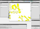
draft of ka-Map installation

2007.January.5

Somewhere Here

Filed under: Alternative GIS, Maps & Cartography — geoLibro @ 11:52 pm

I love this, love this:
The BBC is reporting a story about a letter that was addressed with nothing but a map and delivered as such. Article here.
somewhere here
This story renews my desire to compile user-built, hand-drawn, fake, or otherwise alternative. I intend to call the collection “Punk Maps.” Maybe I should copyright that right now. Anyway, I just came across a book that may have done this, already, anyway. I’m sure there are others (feel free to submit).

2006.October.25

MetaCarta is Where It’s At

Filed under: Alternative GIS, Data Processing and Conversion, Geotagging — geoLibro @ 4:06 am

MetaCarta’s GeoTagger apparently does excellent, impressive, cool work on unstructured documents. The result of its awesomeness is geotagged xml with which one can do whatever one pleases. Make sense? I spoke to a sales rep from MetaCarta at the Indianapolis “What’s New with ArcGIS 9.2” seminar about GeoTagger and grilled him about what could be done. Not too many specifics from that, but then I got a call from the great MetaCarta themselves since I expressed interest. Unless they’re mean-spirited liars, GeoTagger does do natural language processing and does put out very useful xml and does handle versioned data and does include user-specified structured data (think MySQL tables) and does…do more still.

But today’s post is a leech off of Fantom Planet’s post about another slick product built on top of GeoTagger. It’s PageMapper, and you can think of it as a more invasive, more thorough GeoTagThings. Sounds like it’s a little lab-y still, but have you built such a system?

2006.October.8

MetaCarta Must be Where It’s At

Filed under: Alternative GIS, Geotagging, GISUI (GIS User Interfaces) — geoLibro @ 3:53 pm

So the most innovative GIS company extant today really is MetaCarta. Their GTS (Geographic Text Search) makes me very jealous and rue the day I didn’t somehow learn how to develop computer applications and run a GIS company and then think to combine both of them. It’s built on what they call a Geographic Reference Engine, which uses natural language processing to identify geographic references and their contexts within existing text documents. The output is legible from within Google Earth and ArcMap, but my guess is that it could be made to be read by almost anything that’s hip these days.

This is a big deal, if not in practice (I don’t know anybody who has purchased and/or used their GTS), then certainly as a proof-of-implementation that should be of interest to those institutions who are collecting massive amounts of text content electronically and then developing interfaces and other connectors. Say, like, Purdue University Libraries’ Distributed Institutional Repository.

MetaCarta also made GeoTagger, which is essentially a geocoder of existing text collections that outputs xml for use in other contexts.

Anyway, on to the buried lead:
FantomPlanet notes that MetaCarta now has posted an online georeferencing utility that allows anybody with an electronic, unreferenced map document to reference it to its proper place on earth using a series of user-selected control points. There are copyright considerations here, of course (uploading anything means anybody can use it), but at its simplest it’s further proof that MetaCarta gets what’s happening: geospatial information is infiltrating. It’s becoming a common point of access, a common perspective from which we access our documents of any kind. So we’re not imagining, we’re seeing our world of information become mapped, and become accessible by using those maps as interfaces. Not even analysis, which seems like the hangup for so long. That is, GIS for so long was a tool for analysis and data visualization. Now it’s a user interface as well, and librarians who have an interest in normalizing and logicalizing (uh, “to make logical”?) access to information should be pleased. I am, if you take “pleased” to mean “jealous.”

2006.August.12

MetaCarta’s GTS

We first saw MetaCarta’s Geographic Text Search back in 2005. There must be some new functionality or something (document density map, maybe?), because the All Points Blog and others are covering it again. I’m jealous of MetaCarta’s effort more than its existence. It’s the sort of business that a library-based GIS might attend to (especially as more and more library faculty are ushered toward doing interdisciplinary research [with, say, computer scientists]) and it is the sort of project I would really like to develop as a module or other functional component of Purdue’s Institutional Repository project, wherein GIS isn’t analytical but rather an information application almost in and of itself. MetaCarta is using a map interface for non-map, non-GIS document clusters and we should all be interested (but librarians especially) in how these documents are ingested and indexed. If they can do automated geographic indexing of 10,000 documents per day, why don’t more libraries have map interfaces or at least some other geographic utility for locating materials?

2006.August.4

Okay, Listen: About Dapple…

Filed under: Geographic Exploration Systems, GES, GISUI (GIS User Interfaces) — geoLibro @ 1:21 pm

Near the end of July Bull’s rambles mentioned a WorldWind spin-off called Dapple. I didn’t have a way to test it out (I was Mac-only, driving across the country), but James Fee posted a quick review of it. I got a little snide about some user interface stuff (the more Windows I use, the more I become an Apple fanboy), but today let me say that Dapple has some good things going. I recommend everybody try out its WMS implementation at least, and be sure to try out the keyword search function in the table of contents. Ideally, this "lookup" function would be tied to a more standardized, taxonomized vocabulary or catalog (something an enterprising GIS Librarian might want to look into), but it’s still about the only attempt I’ve seen at being able to search for data layers from within the display app (yes, yes, the Mapdex toolbar could be considered). I’d be happy to be corrected on that, by the way.

2006.July.1

OrganicCity

Filed under: Alternative GIS, GISUI (GIS User Interfaces) — geoLibro @ 8:51 pm

atals(t) points to a great map of Oakland at theOrganicCity.com that dots the city with a special kind of attribute: text, audio, and video submitted by lovers (or, potentially I suppose, haters) of Oakland’s neighborhoods, landmarks, scenes, and cultures. I love this kind of melding of (fine: mash-up of) humanities, activism (potentially), and maps. Just as I was leaving Texas A&M International University (I can say “was” because yesterday was my last day) I almost had an opportunity to work on something like this. Old narrated video tapes about the city of Laredo were donated to the library and one of the ways we intended to release this content was via a map interface. I was really looking forward to it, but I confess I am more excited still to be heading off to Purdue in August.

At any rate, enjoy Oakland.

Blog at WordPress.com.